Tag Archive for: aerial maps
 https://gic.org/wp-content/uploads/2022/02/28.004201-82.706977.jpg
720
1280
Angie Brewster
https://gic.org/wp-content/uploads/2021/01/GIC-logo.png
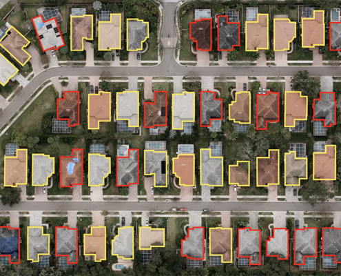
Angie Brewster2022-02-18 17:05:132022-03-28 03:32:21Connecting Insurers to Valuable Imagery with Metadata at Verisk Elevate
https://gic.org/wp-content/uploads/2022/02/28.004201-82.706977.jpg
720
1280
Angie Brewster
https://gic.org/wp-content/uploads/2021/01/GIC-logo.png
Angie Brewster2022-02-18 17:05:132022-03-28 03:32:21Connecting Insurers to Valuable Imagery with Metadata at Verisk Elevate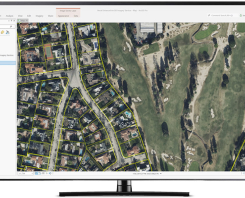 https://gic.org/wp-content/uploads/2022/03/ArcGIS_propertylines-1.jpeg
576
1024
Angie Brewster
https://gic.org/wp-content/uploads/2021/01/GIC-logo.png
Angie Brewster2022-02-15 08:23:552022-03-01 09:25:03Announcing Image Services for ArcGIS
https://gic.org/wp-content/uploads/2022/03/ArcGIS_propertylines-1.jpeg
576
1024
Angie Brewster
https://gic.org/wp-content/uploads/2021/01/GIC-logo.png
Angie Brewster2022-02-15 08:23:552022-03-01 09:25:03Announcing Image Services for ArcGIS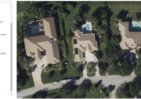 https://gic.org/wp-content/uploads/2022/02/Elements1.png
348
754
Steve Lombardi
https://gic.org/wp-content/uploads/2021/01/GIC-logo.png
Steve Lombardi2022-02-10 11:58:462022-02-25 10:25:37Getting the Most out of Imagery with Elements Property Information
https://gic.org/wp-content/uploads/2022/02/Elements1.png
348
754
Steve Lombardi
https://gic.org/wp-content/uploads/2021/01/GIC-logo.png
Steve Lombardi2022-02-10 11:58:462022-02-25 10:25:37Getting the Most out of Imagery with Elements Property Information https://gic.org/wp-content/uploads/2022/03/Screen-Shot-2022-03-01-at-8.16.51-AM.png
601
1073
Angie Brewster
https://gic.org/wp-content/uploads/2021/01/GIC-logo.png
Angie Brewster2022-02-08 07:59:032022-03-01 13:04:40Introducing MapControl SDK
https://gic.org/wp-content/uploads/2022/03/Screen-Shot-2022-03-01-at-8.16.51-AM.png
601
1073
Angie Brewster
https://gic.org/wp-content/uploads/2021/01/GIC-logo.png
Angie Brewster2022-02-08 07:59:032022-03-01 13:04:40Introducing MapControl SDK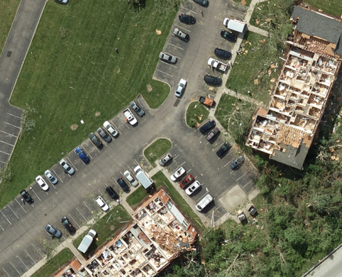 Geospatial Insurance Consortium
https://gic.org/wp-content/uploads/2020/12/Dayton_OH_Aerial_Image_Tornado-1.jpg
563
1000
GIC
https://gic.org/wp-content/uploads/2021/01/GIC-logo.png
GIC2020-12-16 23:43:412020-12-28 15:02:34Tornados, Hurricanes, Wildfires, Oh My—A Year to Remember with Gray Sky
Geospatial Insurance Consortium
https://gic.org/wp-content/uploads/2020/12/Dayton_OH_Aerial_Image_Tornado-1.jpg
563
1000
GIC
https://gic.org/wp-content/uploads/2021/01/GIC-logo.png
GIC2020-12-16 23:43:412020-12-28 15:02:34Tornados, Hurricanes, Wildfires, Oh My—A Year to Remember with Gray Sky