• Help Center
  • Login
geointel.org is now gic.org
Geospatial Insurance Consortium (GIC)
  • Membership
    • Benefits
    • Viewer
    • APIs & Integrations
  • Products
    • Blue Sky Imagery
    • Gray Sky Imagery
    • Elements
  • Use Cases
    • Underwriting
    • Claims
    • CAT Response
    • SIU
    • Innovation
    • Risk Management
  • Blog
  • About
    • Our Vision
    • Videos
  • Menu Menu
  • Home
  • Membership
    • Benefits
    • Viewer
    • APIs & Integrations
  • Products
    • Blue Sky Imagery
    • Gray Sky Imagery
    • Elements
  • Use Cases
    • Underwriting
    • Claims
    • CAT Response
    • SIU
    • Innovation
    • Risk Management
  • Blog
  • About
    • Our Vision
    • Videos

Gray Sky

No one flies more disaster events than the GIC. Get rapid access to high-resolution imagery and data for natural disaster response.

View Gallery

The Gray Sky Advantage

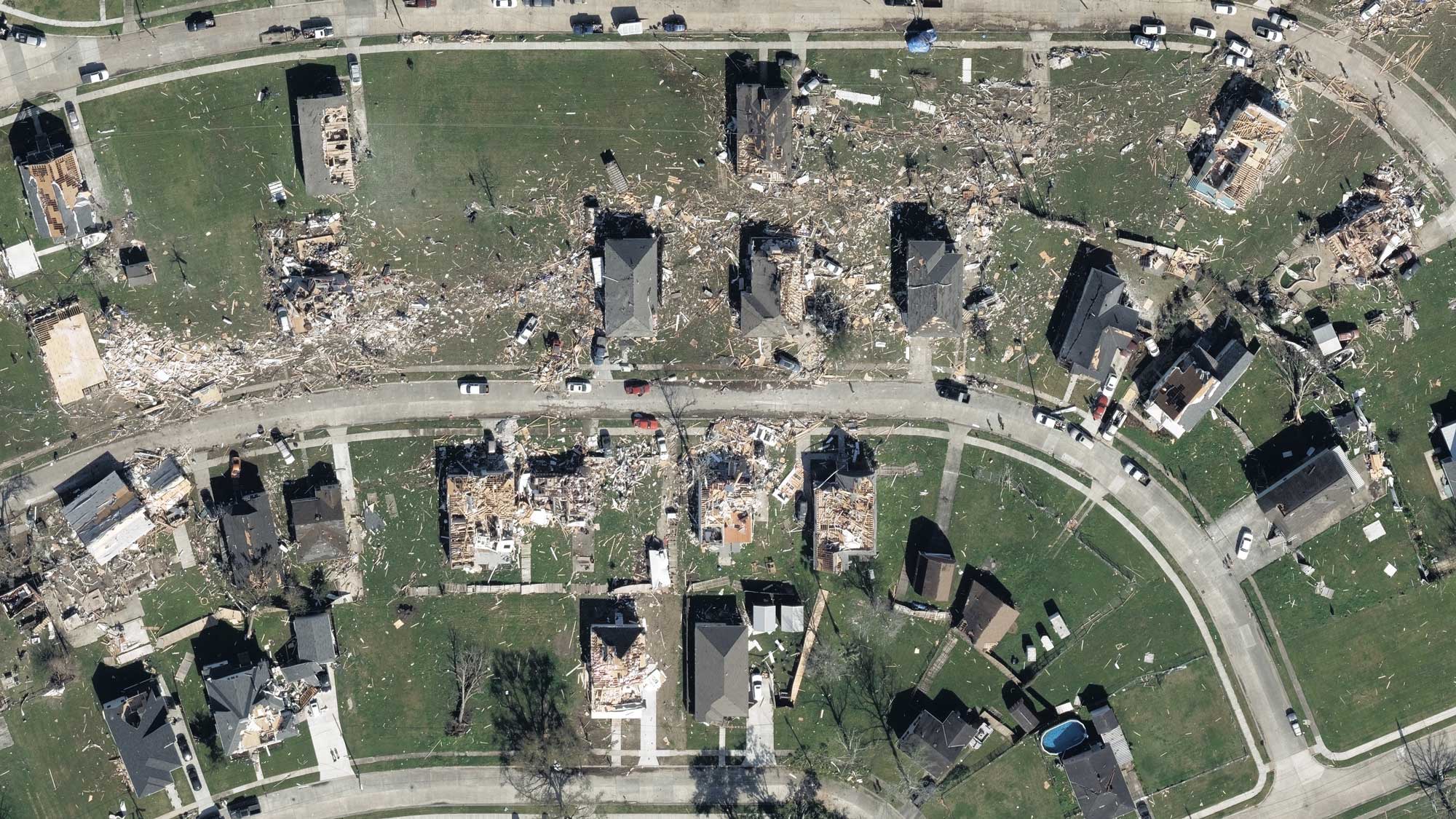
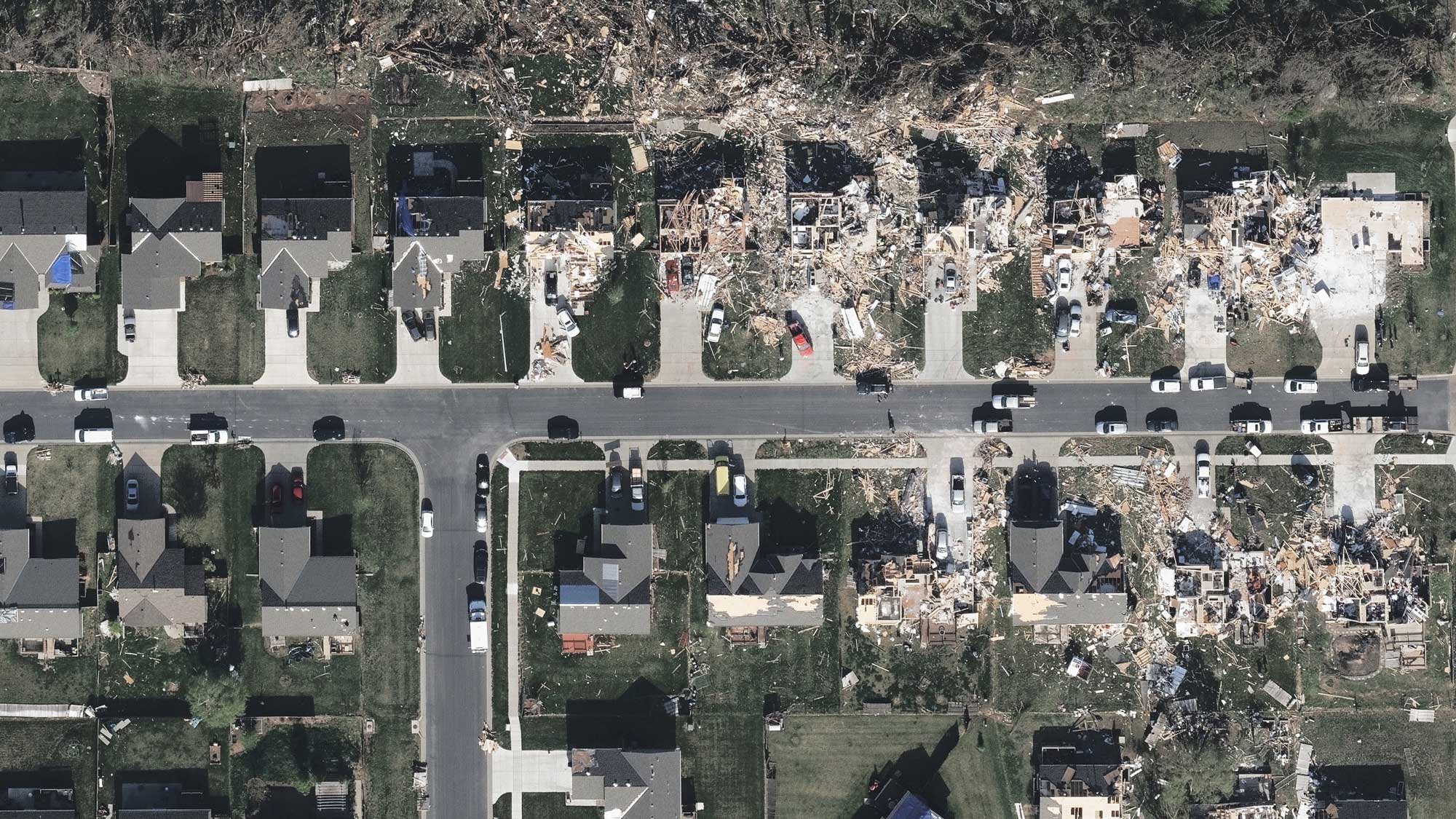
The Gray Sky program is the most comprehensive in the industry when it comes to capturing imagery for a major natural disaster and catastrophe response. The GIC has been covering disasters since Hurricane Harvey struck Texas in 2017. Whether it’s a tornado, hurricane, wildfire, wind, or flooding event, members get the real truth on the ground to serve their business and customer needs more efficiently and effectively.

Rapid Response

As an approved partner with first responders and public safety officials, imagery from CAT events is available within 24 hours of collection. The speed of the response means members can lower claims cycle time, remotely view impacted areas safely, and manage loss mitigation.

Quality Imagery

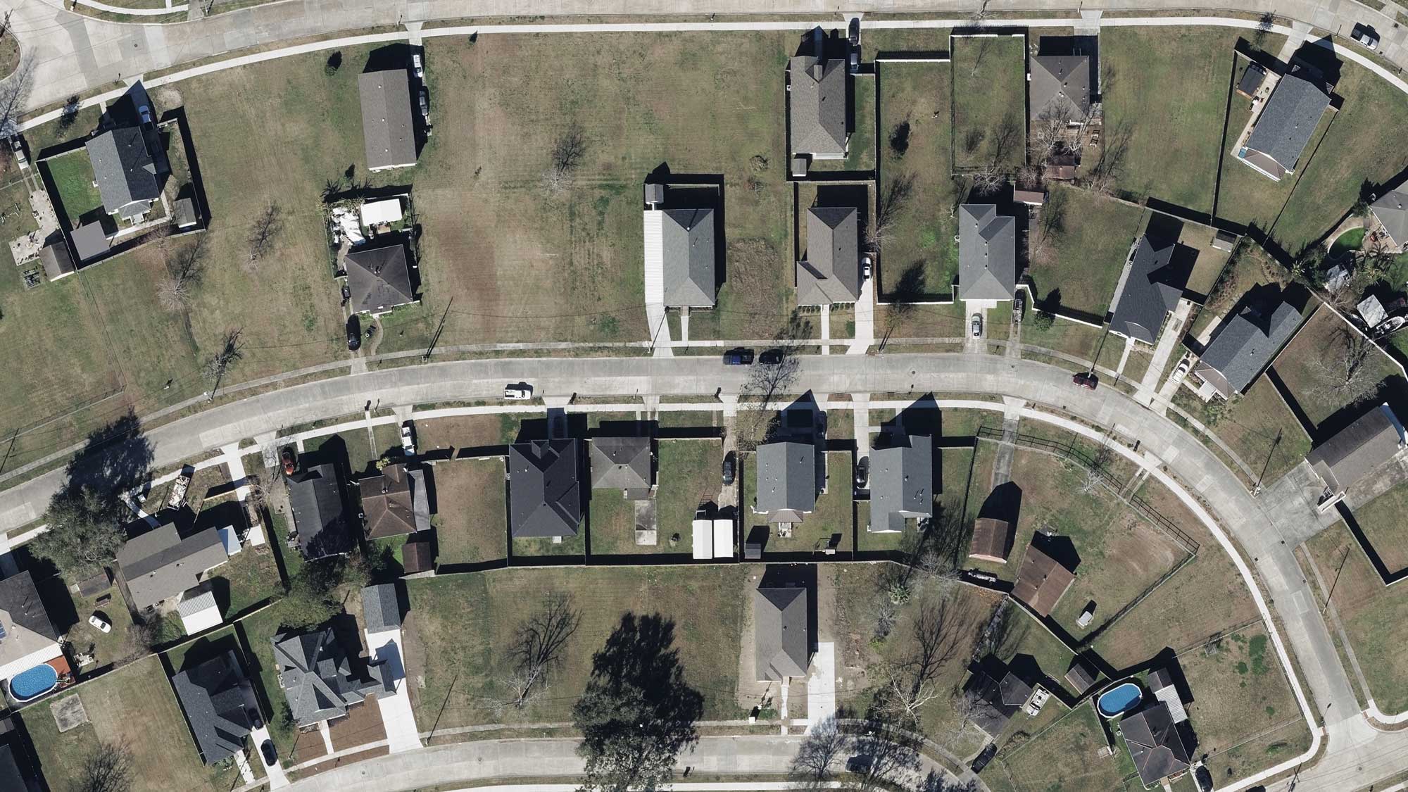
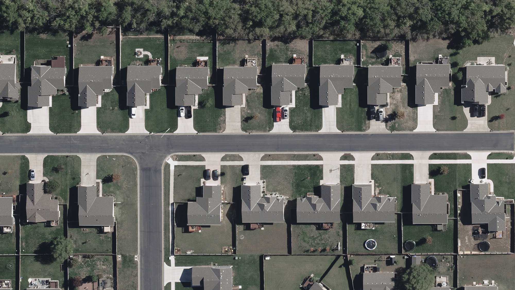
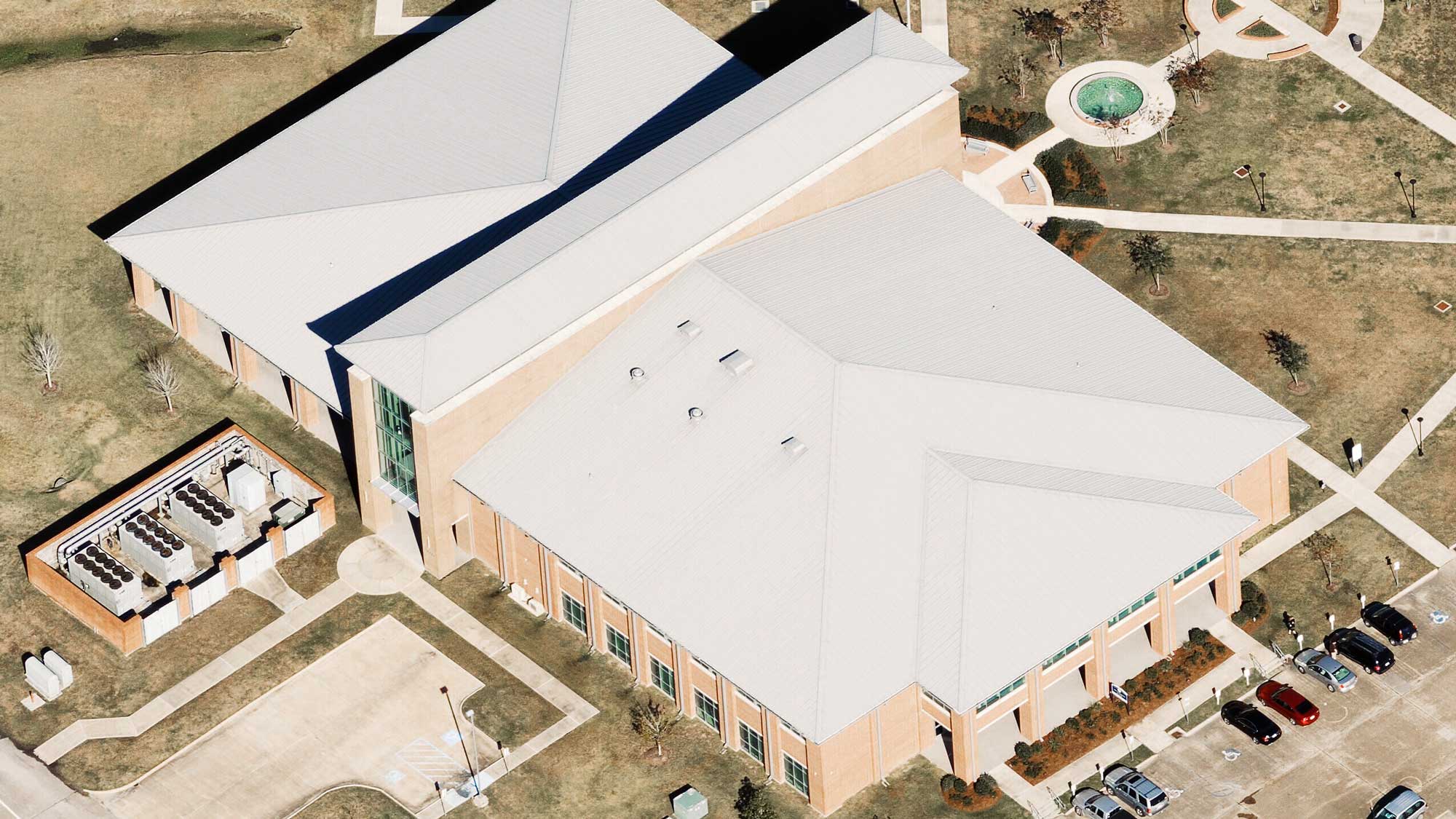
Gray Sky imagery is provided at the highest possible resolution, giving members a clear view of the impact following a CAT event.

Rich AI Data

Disaster and CAT response has been fundamentally changed by using AI. Using the GIC’s robust image library, developers mine every pixel and extract features such as wind-damaged property, burned houses, and tornado paths to provide fast insight at scale.

Types of Disasters

No matter the type of storm or catastrophe, the GIC is poised and ready to respond when disaster strikes. Peruse through a short gallery of Gray Sky events recently captured by our team.

HurricanesFloodsTornadoesWildfiresOther
PreviousNext

Post-CAT Optimized for Insurance

  • Smarter Underwriting

    Streamline underwriting efforts and reduce operating costs with access to current, clear geospatial data

  • Superior Fraud Protection

    Use the GIC’s premium quality imagery to combat fraud, develop remote investigations, and uncover crucial insights

  • Faster, Safer Claims Processing

    When disasters hit, you need rapid access to high-res aerial data, delivered within 24 hours following collection of an event

  • Better Data, Improved Risk Modeling

    Use a wide breadth of location intelligence to more accurately predict threats to specific locations

  • Enhanced Customer Communication

    Respond quickly to customers in crisis by viewing current property conditions in high-resolution

Compare before and after views

By accessing pre- and post-CAT imagery of an impacted area, members quickly identify key ground conditions such as roof blow-off, property damage, flooding, and more.
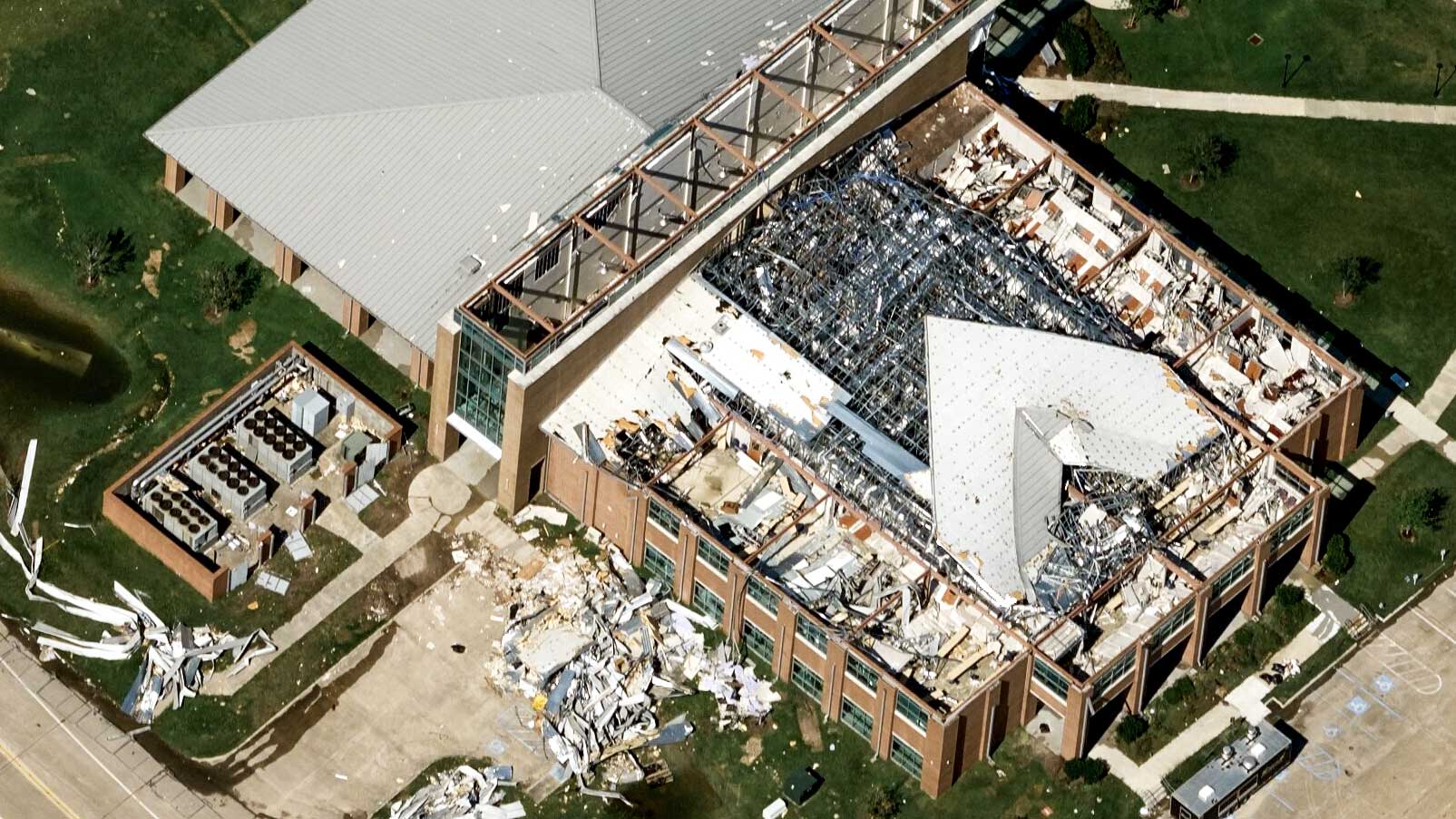
Emergency Responders: Need Timely Post-Cat Imagery?

The GIC provides access to its Gray Sky aerial imagery database to emergency personnel involved in recovery and response efforts to impacted communities. Access to this imagery is available at no cost and with no obligation.

Request Access
 
PreviousNext
GIC member National General Insurance

Request A Demo

Unlock the perfect partnership for insurers.

  • Flexible memberships
  • High-resolution aerial imagery
  • Post-CAT imagery
  • Elevation data & property attributes
  • Top-class support
  • And much more
Contact Us

Membership

Benefits

Viewer App

APIs & Integrations

Products

Blue Sky Imagery

Gray Sky Imagery

Elements

Use Cases

Underwriting

Claims

CAT Response

SIU

Innovation

Risk Management

About

Our Vision

Help Center

Videos

Follow Us


Vexcel Group is the official operations partner of the GIC.

Unleashing information in every pixel. Vexcel Group provides rich geospatial data using best-in-class cameras and sensor technology via a fleet of fixed-wing aircraft. Vexcel delivers the most accurate, consistent aerial imagery and geospatial data on the planet.

Large-format UltraCam cameras & sensors.
vexcel-imaging.com

Aerial surveys by fixed-wing aircraft.
kasurveys.com

Aerial imagery and data for government and business.
vexceldata.com

© Geospatial Insurance Consortium
  • Privacy Policy
  • Terms of Use
  • EULA
Scroll to top

This site uses cookies. By continuing to browse the site, you are agreeing to our use of cookies.

Accept settingsHide notification onlySettings

Cookie and Privacy Settings


How we use cookies

We may request cookies to be set on your device. We use cookies to let us know when you visit our websites, how you interact with us, to enrich your user experience, and to customize your relationship with our website.

Click on the different category headings to find out more. You can also change some of your preferences. Note that blocking some types of cookies may impact your experience on our websites and the services we are able to offer.

Essential Website Cookies

These cookies are strictly necessary to provide you with services available through our website and to use some of its features.

Because these cookies are strictly necessary to deliver the website, refuseing them will have impact how our site functions. You always can block or delete cookies by changing your browser settings and force blocking all cookies on this website. But this will always prompt you to accept/refuse cookies when revisiting our site.

We fully respect if you want to refuse cookies but to avoid asking you again and again kindly allow us to store a cookie for that. You are free to opt out any time or opt in for other cookies to get a better experience. If you refuse cookies we will remove all set cookies in our domain.

We provide you with a list of stored cookies on your computer in our domain so you can check what we stored. Due to security reasons we are not able to show or modify cookies from other domains. You can check these in your browser security settings.

Google Analytics Cookies

These cookies collect information that is used either in aggregate form to help us understand how our website is being used or how effective our marketing campaigns are, or to help us customize our website and application for you in order to enhance your experience.

If you do not want that we track your visit to our site you can disable tracking in your browser here:

Other external services

We also use different external services like Google Webfonts, Google Maps, and external Video providers. Since these providers may collect personal data like your IP address we allow you to block them here. Please be aware that this might heavily reduce the functionality and appearance of our site. Changes will take effect once you reload the page.

Google Webfont Settings:

Google Map Settings:

Google reCaptcha Settings:

Vimeo and Youtube video embeds:

Other cookies

The following cookies are also needed - You can choose if you want to allow them:

Privacy Policy

You can read about our cookies and privacy settings in detail on our Privacy Policy Page.

Privacy Policy
Accept settingsHide notification only
Now Available: Aerial imagery is now available for the Texas tornado.
Learn more
This is default text for notification bar
Learn more