Tag Archive for: Hurricane Michael
 https://gic.org/wp-content/uploads/2018/10/Wreck01.png
541
891
GIC
https://gic.org/wp-content/uploads/2021/01/GIC-logo.png
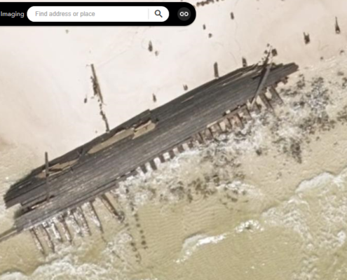
GIC2018-10-22 21:13:372021-04-05 16:41:56100 Year Old Shipwreck Caught from the Sky
https://gic.org/wp-content/uploads/2018/10/Wreck01.png
541
891
GIC
https://gic.org/wp-content/uploads/2021/01/GIC-logo.png
GIC2018-10-22 21:13:372021-04-05 16:41:56100 Year Old Shipwreck Caught from the Sky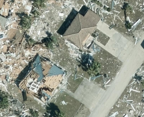 https://gic.org/wp-content/uploads/2021/01/GIC-logo.png
0
0
GIC
https://gic.org/wp-content/uploads/2021/01/GIC-logo.png
GIC2018-10-17 17:37:042021-04-05 16:46:48Damage Assessment layer is now Live
https://gic.org/wp-content/uploads/2021/06/05-StJoeNadir.jpg
745
810
GIC
https://gic.org/wp-content/uploads/2021/01/GIC-logo.png
GIC2018-10-17 02:23:512021-06-21 12:33:19Our first Super Hi Res 360 degree Imagery is online
https://gic.org/wp-content/uploads/2021/01/GIC-logo.png
0
0
GIC
https://gic.org/wp-content/uploads/2021/01/GIC-logo.png
GIC2018-10-16 01:56:332018-10-16 01:56:33GIC Map apps and Services are back online
https://gic.org/wp-content/uploads/2021/01/GIC-logo.png
0
0
GIC
https://gic.org/wp-content/uploads/2021/01/GIC-logo.png
GIC2018-10-15 22:32:502021-04-02 14:51:35Geospatial Intelligence Center Mounts Large Scale Aerial Imaging Response to Hurricane Michael
https://gic.org/wp-content/uploads/2021/01/GIC-logo.png
0
0
GIC
https://gic.org/wp-content/uploads/2021/01/GIC-logo.png
GIC2018-10-15 21:41:042018-10-15 21:41:04UPDATE: Temporary workaround while GIC maps are down
https://gic.org/wp-content/uploads/2021/01/GIC-logo.png
0
0
GIC
https://gic.org/wp-content/uploads/2021/01/GIC-logo.png
GIC2018-10-17 17:37:042021-04-05 16:46:48Damage Assessment layer is now Live
https://gic.org/wp-content/uploads/2021/06/05-StJoeNadir.jpg
745
810
GIC
https://gic.org/wp-content/uploads/2021/01/GIC-logo.png
GIC2018-10-17 02:23:512021-06-21 12:33:19Our first Super Hi Res 360 degree Imagery is online
https://gic.org/wp-content/uploads/2021/01/GIC-logo.png
0
0
GIC
https://gic.org/wp-content/uploads/2021/01/GIC-logo.png
GIC2018-10-16 01:56:332018-10-16 01:56:33GIC Map apps and Services are back online
https://gic.org/wp-content/uploads/2021/01/GIC-logo.png
0
0
GIC
https://gic.org/wp-content/uploads/2021/01/GIC-logo.png
GIC2018-10-15 22:32:502021-04-02 14:51:35Geospatial Intelligence Center Mounts Large Scale Aerial Imaging Response to Hurricane Michael
https://gic.org/wp-content/uploads/2021/01/GIC-logo.png
0
0
GIC
https://gic.org/wp-content/uploads/2021/01/GIC-logo.png
GIC2018-10-15 21:41:042018-10-15 21:41:04UPDATE: Temporary workaround while GIC maps are down