GIS for Disaster Response – Part 3
In this blog series, we interview GIS and emergency management expert, Richard Butgereit, on the use of GIS technologies to improve catastrophe response.
Improving Natural Disaster Recovery Efforts through GIS
In last week’s blog with Richard Butgereit, Director of Catastrophe Response, he explained the role GIS plays in disaster preparedness and management. This week, we hear from Richard on the ways in which GIS and the Geospatial Intelligence Center’s partnership with the private sector improves recovery efforts, allowing communities to rebuild faster.
Can you tell us why the post-disaster assessment process is critical to recovery efforts?
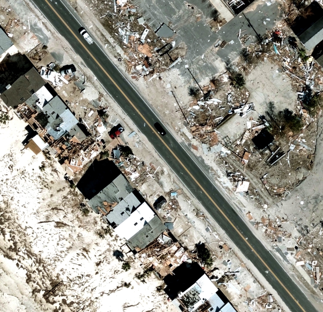
Richard: “Post-disaster damage assessment is what drives the recovery effort after a natural disaster. Affected areas need to be assessed to ascertain how many houses were destroyed or how many people no longer have a place to go to work or to live. Once the affected areas have been assessed, this information is then used to scope and begin the recovery process with the goal of making a community whole again.”
How has post-disaster data collection enhanced recovery efforts?
Richard: “If you look at the adoption of post-disaster imagery made available to emergency management organizations and stakeholders, it’s a constant evolution. Years ago we had disasters like Hurricane Katrina in which the response nor recovery efforts were well coordinated at the very beginning. We saw quickly that a lack of organization and resources could have a tremendous impact on outcomes after a disaster.
Like with so many disasters, in the immediate aftermath of Hurricane Katrina, post-disaster imagery collection efforts were in direct conflict with critical search and rescue operations, delaying data collection. And unfortunately, the data collected didn’t show up to emergency operations centers until several weeks after the storm – and even then, the data collected was hard to assess due to the lack of an index and inability to understand which locations at which time were covered by the imagery. As a result, it wasn’t effectively leveraged to positively affect outcomes.
Fast forward to today, the lessons learned along with advancements in technology and the development of programs like the Geospatial Intelligence Center, and we now have unprecedented post-disaster data collection coordinated as a component of the response, capturing unprecedented quantities of quality, high-resolution data that can be turned around in quicker time frames than ever previously possible and contributing to recovery.
The end result is critical to the rebuilding of communities. In addition to serving our GIC member insurers, the GIC can share this same post-disaster data with emergency responders and government organizations like FEMA that can be used immediately to change outcomes for families, businesses, and communities that have been impacted – helping them get back on their feet faster.”
What ways can geospatial analytics be used in combination with imagery to provide the most comprehensive response?
Richard: “I see two base feeds of information following disasters, one driven from the public sector and one driven from the private sector. Each can drive disaster response and recovery, but they work best, and most effectively for the communities impacted, when the data can be shared across these domains.
On the public side, data feeds include FEMA’s Individual Assistance Program, where phone calls and registration for aid are being initiated. This information is one indicator of the areas and levels of damage that a person’s home or business has endured. On the private side, insurers are a critical resource to people affected by these disasters. From their respective positions, how can this data be de-identified and aggregated to foster this cross-domain data sharing?
I remember working in the Florida emergency operations center and observing as the US National Grid, a tactical tool originally created to improve search and rescue ground operations, naturally through geospatial analytics revealed itself as a strategic tool for data de-identification and aggregation.
Even as more sophisticated geospatial analytics like machine learning and artificial intelligence evolve around us, including using GIC post-disaster imagery, that same imagery is being used today to drive comprehensive response. When responders and emergency managers gather around our imagery, conversations and connections are spawned. And from those, we can logically dive into further data sharing discussions and work to assist communities affected by natural disasters. This type of partnership is a true game-changer in disaster response.”

 Geospatial Insurance Consortium