GIC Collects Imagery over Kincade Fire in Sonoma County
The Kincade Fire has now impacted 76,825 acres in Sonoma County, CA, and is at 45 percent containment as of the last report. According to Cal Fire, a total of 266 structures have been destroyed, 133 being residential, and 47 structures have been damaged, with 32 of those being residential. On Tuesday, in response to the incident, the Geospatial Intelligence Center (GIC) began flying over the impacted areas, collecting high-resolution aerial images of the damaged structures. The imagery was made available to GIC members yesterday afternoon.
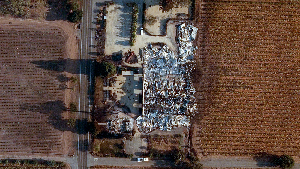
Kincade Fire in Sonoma County, CA
The imagery gives insurers the ability to search an address and view before and after aerial images of properties within the impacted area. These images provide insurers with vital information to better respond and pay claims faster to victims while increasing fraud detection. The imagery is also provided at no cost to emergency personnel, first responders, and law enforcement to assist in their response to the damage.
“The communities affected by this fire are suffering. Firefighters won a huge battle last night, and instead of exploding further, crews managed to hold expansion to just a few hundred acres and double containment,” said Richard Butgereit, director of catastrophe response, GIC. “This marks a turning point for this fire and these communities. Recovery begins with post-disaster damage assessment. It is our hope that by quickly getting high-resolution aerial imagery to our GIC members and public safety stakeholders to assess these damages, we can help speed up the recovery process with the goal to ease this suffering and make these communities whole again.”
In 2017, the NICB started searching for solutions to help its member companies and law enforcement advance technology post-disaster by developing the Geospatial Intelligence Center Program (GIC) that licenses high-resolution aerial images from Vexcel Imaging US, Inc.
“In order to help fight fraud, in the hours and days after a disaster like this one, the GIC fleet of aircraft will fly over impacted areas to capture and assess damage providing members with unprecedented imagery and data on impacted properties,” said Jim Schweitzer, senior vice president and COO, NICB. “This not only so we can serve our members better, but also stop fraudulent insurance claims, which ultimately drive up insurance costs for everyone. Educating consumers is critical. When a deal seems too good to be true, it probably is, so we encourage homeowners to make their first call to their insurance company before moving forward with a contractor.”

 Geospatial Insurance Consortium
 Geospatial Insurance Consortium