NEW: Building Footprints and Property Attributes for U.S. & Australia
Note: Our operations partner, Vexcel, has announced building footprints and property attributes for U.S. and Australia. These new data sets will be available to the GIC and its insurer members. Ask your member advocate for more details and a demo today. Read the news release below.
October 5, 2021 – The world’s largest aerial imagery program, Vexcel Data Program announced the addition of building footprints and property attributes to its geospatial information content covering Australia and U.S. These new data sets enhance the company’s best-in-class aerial imagery by adding extra layers of visualization, measurements, and valuable attributes at the property level.
The new products cover millions of buildings and dwellings in the metro areas of Australia and U.S. The new data will rollout in both countries and will be available soon to customers.
“Providing building footprints and property attributes helps our customers find greater value in our global data,” said Erik Jorgensen, CEO of Vexcel Group. “Customers get a significant advantage in their visualization of properties and enhancing their analytics to a substantial degree.”
A Powerful Data Set
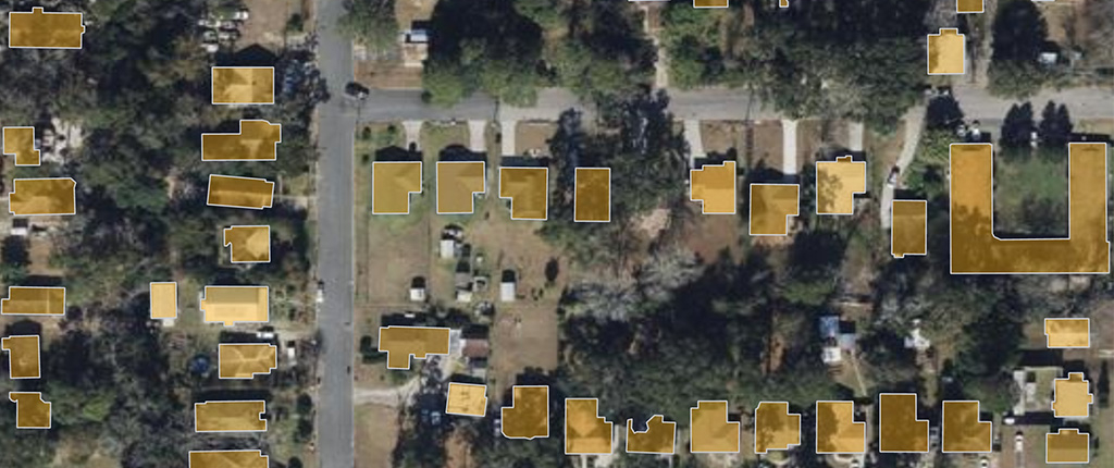
Building footprints data is created and derived from Vexcel’s Urban Area program, an aircraft-based collection of ultra-high resolution aerial imagery and digital surface models. Camera sensors, designed and manufactured by Vexcel Imaging, are radiometrically and geometrically calibrated to collect the highest quality aerial imagery in the market. This best-in-class imagery is then used to auto-generate a highly detailed geometry of building outlines so customers can better understand and visualize what’s on the ground beyond just an image.
Along with the footprints, customers can identify, extract, and analyze property-level attributes including swimming pools, trampolines, solar panels, vegetation types, roof types, building materials, and more.
Access to these products are supported through Vexcel’s web-based applications, APIs, and standard map services.
Valuable Property Insights for Many Industries
The demand for property-level details continues to grow for insurance, government, telecommunications, and utilities. Insurers can evaluate risk for underwriting, see property and building features, and identify vegetation for things like defensible spaces in wildfire-prone areas. Tax assessors can track changes to building structures to update tax rolls. Telecom companies can determine the impact of a building’s footprint against line-of-sight for transmitters.
Trusted Accuracy at an Unprecedented Scale
Vexcel aerial imagery and geospatial information is positioned against ground control points for unmatched accuracy and quality. With the Urban Area collection, True Ortho and Oblique imagery is collected at 7.5 centimeters (2.9 inches) ground sample distance with the award-winning UltraCam Osprey 4.1 sensors from Vexcel Imaging.


 GIC
GIC