 https://gic.org/wp-content/uploads/2017/10/web-map-10.02.2017.png
957
936
GIC
https://gic.org/wp-content/uploads/2021/01/GIC-logo.png
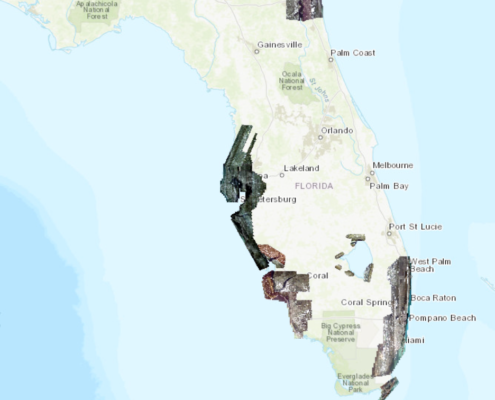
GIC2017-10-02 11:03:282017-10-02 11:03:28Additional Okeechobee Imagery on Web App
https://gic.org/wp-content/uploads/2021/01/GIC-logo.png
0
0
GIC
https://gic.org/wp-content/uploads/2021/01/GIC-logo.png
GIC2017-10-01 10:23:112017-10-01 10:23:11All Okeechobee Blocks Collected, Processed and Uploaded
https://gic.org/wp-content/uploads/2021/01/GIC-logo.png
0
0
GIC
https://gic.org/wp-content/uploads/2021/01/GIC-logo.png
GIC2017-09-30 09:45:102017-09-30 09:45:10Addtional Imagery Added to GIC Map Application
https://gic.org/wp-content/uploads/2021/01/GIC-logo.png
0
0
GIC
https://gic.org/wp-content/uploads/2021/01/GIC-logo.png
GIC2017-09-29 20:30:082017-09-29 20:30:08Okeechobee Upload Progress Update
https://gic.org/wp-content/uploads/2021/01/GIC-logo.png
0
0
GIC
https://gic.org/wp-content/uploads/2021/01/GIC-logo.png
GIC2017-09-29 09:40:272017-09-29 09:40:27Additional Data Processed and Uploaded
https://gic.org/wp-content/uploads/2021/01/GIC-logo.png
0
0
GIC
https://gic.org/wp-content/uploads/2021/01/GIC-logo.png
GIC2017-09-28 18:25:212017-09-28 18:25:21Okeechobee 3″ Nadir/Oblique Acquisition Progress
https://gic.org/wp-content/uploads/2017/10/web-map-10.02.2017.png
957
936
GIC
https://gic.org/wp-content/uploads/2021/01/GIC-logo.png
GIC2017-10-02 11:03:282017-10-02 11:03:28Additional Okeechobee Imagery on Web App
https://gic.org/wp-content/uploads/2021/01/GIC-logo.png
0
0
GIC
https://gic.org/wp-content/uploads/2021/01/GIC-logo.png
GIC2017-10-01 10:23:112017-10-01 10:23:11All Okeechobee Blocks Collected, Processed and Uploaded
https://gic.org/wp-content/uploads/2021/01/GIC-logo.png
0
0
GIC
https://gic.org/wp-content/uploads/2021/01/GIC-logo.png
GIC2017-09-30 09:45:102017-09-30 09:45:10Addtional Imagery Added to GIC Map Application
https://gic.org/wp-content/uploads/2021/01/GIC-logo.png
0
0
GIC
https://gic.org/wp-content/uploads/2021/01/GIC-logo.png
GIC2017-09-29 20:30:082017-09-29 20:30:08Okeechobee Upload Progress Update
https://gic.org/wp-content/uploads/2021/01/GIC-logo.png
0
0
GIC
https://gic.org/wp-content/uploads/2021/01/GIC-logo.png
GIC2017-09-29 09:40:272017-09-29 09:40:27Additional Data Processed and Uploaded
https://gic.org/wp-content/uploads/2021/01/GIC-logo.png
0
0
GIC
https://gic.org/wp-content/uploads/2021/01/GIC-logo.png
GIC2017-09-28 18:25:212017-09-28 18:25:21Okeechobee 3″ Nadir/Oblique Acquisition Progress