GIC Collects Wildfire Imagery Across The Western U.S.
High Resolution Imagery Is Now Available to Help Insurers Respond Safer and Faster to Recent Wildfire Disasters
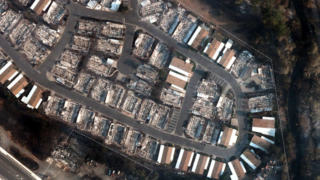
As wildfires continue to rage across the western United States, the Geospatial Insurance Consortium (GIC) is flying aircraft over impacted areas to collect high-resolution aerial images and data of damaged structures. The GIC enables a property-by-property view of recent Western wildfire devastation.
Wildfire damage near Medford, Oregon.
The GIC has rapidly responded by collecting wildfire imagery in Oregon, California, Washington, and Montana, giving insurers the ability to search for addresses to view before and after aerial images of impacted properties. Imagery is collected as weather and smoke conditions permit then processed and available to GIC members within 24 hours of collection. If your organization needs access to GIC imagery, email info@geointel.org.
Current GIC post-catastrophe wildfire imagery includes:
• Alameda Drive-Glendower-Obenchain Fires in Jackson County, Oregon
• Bear-North Complex in Butte County, California
• Creek Fire in Fresno and Madera Counties, California
• Bridger Foothills in Gallatin County, Montana
• Babb Fire in Whitman County, Washington
The GIC continues to monitor conditions and collect in key areas, including several other large fires in Oregon and California. The GIC also prioritizes future imagery collections based on ongoing feedback from GIC members and government stakeholders.
Geospatial images from the GIC help provide insurers with vital information to better respond to and settle claims faster while mitigating potential fraud. In addition, this imagery is provided at no cost to emergency personnel, first responders, and law enforcement to assist in their response to the damage.
“With devastating wildfires like these, damage assessment is crucial to expedite the recovery process. We know that post-disaster, high-resolution aerial imagery can speed up the recovery process allowing claims processing to proceed faster as well as obtain benchmark information to prevent fraud for our GIC members,” said Richard Butgereit, Director of Catastrophe Response, GIC.
In areas like Malden, Washington, officials estimate as many as 80% of structures have been destroyed, including critical infrastructure. “This imagery can assist with long-term recovery or inform a distressed home or business owner that their property is still standing,” Butgereit added.
“Technological advances have improved in recent years, providing insurers with critical tools to enhance fraud detection and expedite fraud investigations. The GIC is just another example of how the industry is leveraging innovation to help fight fraud in the wake of a disaster like this one,” said NICB’s Senior Vice President and Chief Operating Officer Timothy Slater.
“Following any major disaster, we unfortunately see scammers swoop in to take advantage of homeowners promising a quick fix. In some cases, it’s the homeowner who might want a new roof and attempt to scam the insurance company. Regardless, it’s a problem and we must as an industry continue to develop innovative crime fighting solutions to stop this from happening,” added Slater.
This imagery and data can be used for real-time collaboration between teams — both on the ground and from remote offices – to make better, faster decisions on behalf of their customers. Earlier in 2020, the GIC renamed itself to Geospatial Insurance Consortium from the Geospatial Intelligence Center.

 Geospatial Insurance Consortium
 Geospatial Insurance Consortium