• Help Center
  • Login
geointel.org is now gic.org
Geospatial Insurance Consortium (GIC)
  • Membership
    • Benefits
    • Viewer
    • APIs & Integrations
  • Products
    • Blue Sky Imagery
    • Gray Sky Imagery
    • Elements
  • Use Cases
    • Underwriting
    • Claims
    • CAT Response
    • SIU
    • Innovation
    • Risk Management
  • Blog
  • About
    • Our Vision
    • Videos
  • Menu Menu
  • Home
  • Membership
    • Benefits
    • Viewer
    • APIs & Integrations
  • Products
    • Blue Sky Imagery
    • Gray Sky Imagery
    • Elements
  • Use Cases
    • Underwriting
    • Claims
    • CAT Response
    • SIU
    • Innovation
    • Risk Management
  • Blog
  • About
    • Our Vision
    • Videos

[elements]

Damage Assessment

Rapid property insights for post-CAT wind and fire disasters

Catastrophic Weather Trends Demand Powerful Property Analytics

As destructive weather patterns grow globally, the need for rapid property insights becomes a necessity. Climate analysts have attributed rising global temperatures to the escalating spate of tornadoes, hurricanes, and wildfires. And with these disasters comes the inevitable aftermath of destruction and despair for communities needing to rebuild. This type of weather is also transforming the insurance landscape, creating new opportunities to employ technology and tools, such Damage Assessment, to aid in managing claims and risk for insurers big and small.

Use Damage Details to Proactively Help Impacted Customers

When catastrophic weather hits, our members are on high alert, anxiously awaiting the Gray Sky imagery we collect to match against their PIFs. By applying machine learning across the GIC’s high-resolution Gray Sky aerial imagery, automated insights can be delivered in seconds. Starting with location coordinates, members can pull damaged structures, highlight the customers in greatest need, then proactively reach out to those impacted to begin the claims process–all without ever needing to set a foot on the ground.

Post-CAT Property Awareness in Seconds

With Damage Assessment, multiple pieces of information on a damaged building can give members context to real truth on the ground. By accessing information beyond what’s discernible to the eye, members can quickly categorize the damage in multiple ways, from an overall CAT score to how much roof material is missing to debris coverage. These additional property insights can help members scale their responses with greater agility, verifying which policy holders have damaged property. This report will be available shortly after Gray Sky collection and will cover every property that falls within a natural disaster impacted zone.

Manage Resources, Shore Up Risk with Detailed Information

Access to these automatically calculated property analytics provides numerous benefits to GIC members. Using this data, members can:

  • Better manage and scale responses to heavily impacted customers
  • Proactively identify policy holders with damaged property and begin the claims process immediately
  • Deploy resources, i.e, field adjusters, more effectively and safely with detailed information for remote assessment on damaged structures
  • Pinpoint key learnings to shore up underwriting and risk policies for future events

Compare Before and After Views

Historical imagery provides another layer of information members can use to validate changes and reduce uncertainty when processing a claim. By comparing the Damage Assessment report to the GIC’s Blue Sky imagery, members can quickly verify valid destruction on a property to triage and assess loss.

Attributes for Damage Assessment

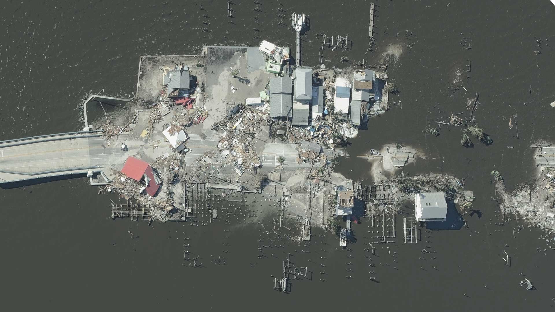
Get building damage information quickly by using Damage Assessment on the GIC’s Gray Sky imagery. The product helps deliver automatically calculated data, helping streamline your PIF assessment by rating the damage a building sustained from a wind or fire event.

  • BEFORE DISASTER
  • Footprint area
  • Ground elevation
  • Roof condition
  • Roof centroid location (wkt)
  • Roof material
  • Roof discoloration
  • Roof shape
  • Roof solar
  • Tree cover over roof
  • Defensible space report
  • Primary structure
  • AFTER DISASTER
  • Damage footprint
  • Catastrophe Score
  • Approx. FEMA classification
  • Roof structure damage
  • Roof missing material
  • Tarp covering roof
  • Debris on roof
  • Damaged roof discoloration

 
PreviousNext
GIC member National General Insurance

Request A Demo

Unlock the perfect partnership for insurers.

  • Flexible memberships
  • High-resolution aerial imagery
  • Post-CAT imagery
  • Elevation data & property attributes
  • Top-class support
  • And much more
Contact Us

Membership

Benefits

Viewer App

APIs & Integrations

Products

Blue Sky Imagery

Gray Sky Imagery

Elements

Use Cases

Underwriting

Claims

CAT Response

SIU

Innovation

Risk Management

About

Our Vision

Help Center

Videos

Follow Us


Vexcel Group is the official operations partner of the GIC.

Unleashing information in every pixel. Vexcel Group provides rich geospatial data using best-in-class cameras and sensor technology via a fleet of fixed-wing aircraft. Vexcel delivers the most accurate, consistent aerial imagery and geospatial data on the planet.

Large-format UltraCam cameras & sensors.
vexcel-imaging.com

Aerial surveys by fixed-wing aircraft.
kasurveys.com

Aerial imagery and data for government and business.
vexceldata.com

© Geospatial Insurance Consortium
  • Privacy Policy
  • Terms of Use
  • EULA
Scroll to top

This site uses cookies. By continuing to browse the site, you are agreeing to our use of cookies.

Accept settingsHide notification onlySettings

Cookie and Privacy Settings


How we use cookies

We may request cookies to be set on your device. We use cookies to let us know when you visit our websites, how you interact with us, to enrich your user experience, and to customize your relationship with our website.

Click on the different category headings to find out more. You can also change some of your preferences. Note that blocking some types of cookies may impact your experience on our websites and the services we are able to offer.

Essential Website Cookies

These cookies are strictly necessary to provide you with services available through our website and to use some of its features.

Because these cookies are strictly necessary to deliver the website, refuseing them will have impact how our site functions. You always can block or delete cookies by changing your browser settings and force blocking all cookies on this website. But this will always prompt you to accept/refuse cookies when revisiting our site.

We fully respect if you want to refuse cookies but to avoid asking you again and again kindly allow us to store a cookie for that. You are free to opt out any time or opt in for other cookies to get a better experience. If you refuse cookies we will remove all set cookies in our domain.

We provide you with a list of stored cookies on your computer in our domain so you can check what we stored. Due to security reasons we are not able to show or modify cookies from other domains. You can check these in your browser security settings.

Google Analytics Cookies

These cookies collect information that is used either in aggregate form to help us understand how our website is being used or how effective our marketing campaigns are, or to help us customize our website and application for you in order to enhance your experience.

If you do not want that we track your visit to our site you can disable tracking in your browser here:

Other external services

We also use different external services like Google Webfonts, Google Maps, and external Video providers. Since these providers may collect personal data like your IP address we allow you to block them here. Please be aware that this might heavily reduce the functionality and appearance of our site. Changes will take effect once you reload the page.

Google Webfont Settings:

Google Map Settings:

Google reCaptcha Settings:

Vimeo and Youtube video embeds:

Other cookies

The following cookies are also needed - You can choose if you want to allow them:

Privacy Policy

You can read about our cookies and privacy settings in detail on our Privacy Policy Page.

Privacy Policy
Accept settingsHide notification only
Now Available: Aerial imagery is now available for the Texas tornado.
Learn more
This is default text for notification bar
Learn more