 https://gic.org/wp-content/uploads/2022/11/36.789078-174.500309-copy-1.jpg
941
1674
Angie Brewster
https://gic.org/wp-content/uploads/2021/01/GIC-logo.png
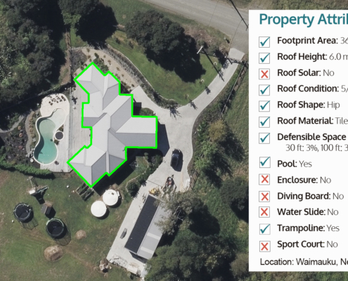
Angie Brewster2022-11-04 08:04:242022-11-04 11:41:10Now Available: Property Attributes for New Zealand
https://gic.org/wp-content/uploads/2022/11/36.789078-174.500309-copy-1.jpg
941
1674
Angie Brewster
https://gic.org/wp-content/uploads/2021/01/GIC-logo.png
Angie Brewster2022-11-04 08:04:242022-11-04 11:41:10Now Available: Property Attributes for New Zealand https://gic.org/wp-content/uploads/2022/10/03-Hurricane-Caguas-Fiona-US-PR-after.jpg
720
1280
GIC
https://gic.org/wp-content/uploads/2021/01/GIC-logo.png
GIC2022-10-12 10:24:222022-10-12 11:53:13Gray Sky Event: Hurricane Fiona in Puerto Rico
https://gic.org/wp-content/uploads/2022/10/03-Hurricane-Caguas-Fiona-US-PR-after.jpg
720
1280
GIC
https://gic.org/wp-content/uploads/2021/01/GIC-logo.png
GIC2022-10-12 10:24:222022-10-12 11:53:13Gray Sky Event: Hurricane Fiona in Puerto Rico https://gic.org/wp-content/uploads/2022/09/True-ortho.jpeg
576
1024
Angie Brewster
https://gic.org/wp-content/uploads/2021/01/GIC-logo.png
Angie Brewster2022-09-12 11:01:142022-09-15 11:07:22GIC’s Operations Partner, Vexcel, Announces New Partnership with Arturo
https://gic.org/wp-content/uploads/2022/09/True-ortho.jpeg
576
1024
Angie Brewster
https://gic.org/wp-content/uploads/2021/01/GIC-logo.png
Angie Brewster2022-09-12 11:01:142022-09-15 11:07:22GIC’s Operations Partner, Vexcel, Announces New Partnership with Arturo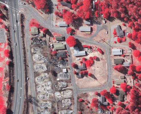 https://gic.org/wp-content/uploads/2022/09/Mill-Fire-graysky-multispectral-2.jpeg
720
1280
Angie Brewster
https://gic.org/wp-content/uploads/2021/01/GIC-logo.png
Angie Brewster2022-09-09 10:20:422022-12-27 09:24:16Gray Sky Event: Mill and McKinney Fires
https://gic.org/wp-content/uploads/2022/09/Mill-Fire-graysky-multispectral-2.jpeg
720
1280
Angie Brewster
https://gic.org/wp-content/uploads/2021/01/GIC-logo.png
Angie Brewster2022-09-09 10:20:422022-12-27 09:24:16Gray Sky Event: Mill and McKinney Fires https://gic.org/wp-content/uploads/2022/07/Screen-Shot-2022-07-26-at-11.43.46-AM.png
405
641
Angie Brewster
https://gic.org/wp-content/uploads/2021/01/GIC-logo.png
Angie Brewster2022-07-26 11:42:202022-07-26 11:44:51Introducing Building Attributes–Insights for Millions of Properties
https://gic.org/wp-content/uploads/2022/07/Screen-Shot-2022-07-26-at-11.43.46-AM.png
405
641
Angie Brewster
https://gic.org/wp-content/uploads/2021/01/GIC-logo.png
Angie Brewster2022-07-26 11:42:202022-07-26 11:44:51Introducing Building Attributes–Insights for Millions of Properties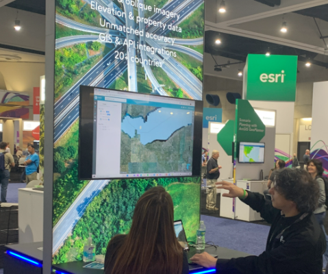 https://gic.org/wp-content/uploads/2022/07/Screen-Shot-2022-07-27-at-10.22.38-AM.png
448
479
Angie Brewster
https://gic.org/wp-content/uploads/2021/01/GIC-logo.png
Angie Brewster2022-07-19 10:29:372022-07-27 16:08:12Esri UC 2022: Highlighting Our Elements Products for Insurers
https://gic.org/wp-content/uploads/2022/07/Screen-Shot-2022-07-27-at-10.22.38-AM.png
448
479
Angie Brewster
https://gic.org/wp-content/uploads/2021/01/GIC-logo.png
Angie Brewster2022-07-19 10:29:372022-07-27 16:08:12Esri UC 2022: Highlighting Our Elements Products for Insurers
